Sunday, March 9, 2008

Bonneville Dam to Washougal


Well, another sunny day paddling with Jon Walpole and friends.

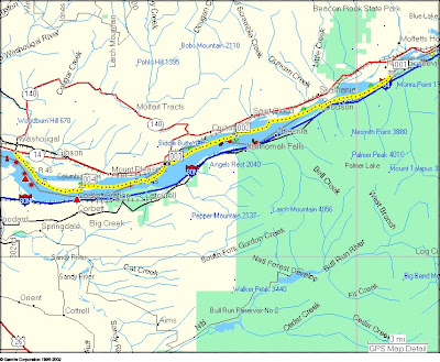
Jon was looking for a nice kayak trip for this Sunday. The Columbia Gorge was an option. The weather prediction for today in the Columbia Gorge was for E winds 11-17, gusting to 25 (mph). 20% chance of rain. Though the tidal influence at Bonneville is small, the tide would be ebbing all the time we'd be paddling. (High tide Vancouver: 9:23am, low 17:39.) Not bad. So he planned a trip from Bonneville Dam to Washougal. I'd never paddled that part of the Columbia so I was definitely up for it.

Jon, Jenny and I met at Steamboat Landing in Washougal at 9am (a civilized time - I'd even had time for coffee and breakfast). We took Jon's car up to the boat ramp on Hamilton Island for our launch. As we drove to the boat ramp we got an awe-inspiring view of massive amounts of water coming over the Bonneville Dam spillway. Now, I'd never been to this spot... but the boat ramp seemed awfully close to the dam's spillway if you ask me. And the really big red sign just a few feet east of the boat ramp that said something like "Danger - Do not proceed past this point" also was pause for reflection. Still, we got gear situated, did warm up exercises, etc. As we were getting ready pair of bald eagles flew by. A good omen to be sure.

The boat ramp itself runs into a little eddy. We launched, and leaving the eddy into the main channel turned out to be a very pleasant little bit of acceleration to start our voyage and not the Deception Pass eddy peel-out I was expecting. We got on the water at 10:20.

On the chart it's clear that the Columbia is pretty narrow at that point, but it was striking to actually be there. It really feels narrow. And alot of water moving. We were paddling gently yet cruising along at a nice rate of knots. In that area of strong current we were often going 10 mph: 8.7 kt! I was thrilled.

We did a bit of eddy play here and there. Some impressive eddylines. Not Deception Pass, but alot more conveniently located!

Of course the river soon widened and the current slowed to pretty much what you'd expect -- appr. 2 kt. We got more current here and there, but never got going that fast again on this voyage.

During the early part of the trip there was next to no wind. So the current was a great help. After awhile the wind picked up, but it never got to the promised 17 mph and I'm sure I never felt a 25 mph gust. But the wind did pick up to appr 15 mph and we got some small waves. These small waves were great for practice. Trying to eek as much energetic help from them as I could. And lots of opportunities for really working on getting my speed right for catching a wave, stern rudder, etc.

We stopped for lunch on Skamania Island. Jon and I told Jenny stories about hiking and climbing in Scotland. The sun baking down :)

After lunch the 15 mph E wind was still helping us. We continued to work on catching those small waves. We planned to pull into the eddy behind Phoca Rock to relax. But as we approached we saw that there were at least ten sea lions hauled out on the rock. As we passed they clearly weren't happy with us. My they can be noisy! And big! And about the time we were going to pull into the eddy behind Phoca Rock the all jumped into the water. I was sure they were heading for us! So... we didn't pause there. Where are the orcas when you need 'em?

We meandered at the base of some beautiful basalt cliffs at Cape Horn. Some nice waterfalls. Some nice spots to play among the rocks.

We did pause for a break at the east end of Reed Island. Then off for the final bit back to Steamboat Landing. As we neared Washougal the wind died completely and it felt like summer. We made use of the calm water to practice paddling in reverse for awhile. Always good to do.

Then were were back just before 4pm. A total of 19.33 nm -- 22.3 miles! Our moving average speed was 4.2 kt across the entire day. Max speed: 9.7 kt :) Moving time: 4hr 32min.

Easily the most distance I've ever covered paddling on a day trip. And I felt great at the end of the day. I've definitely had days when I was much more tired after not covering as much distance - like every BCU 4 star training I've had the good fortune to take (a heartfelt thank-you to Shawna and Leon and Karl and John Wallum).

What a great day. We had beautiful weather. Great company. The current helped us out. We saw eagles and a falcon of some variety. More sea lions that I'd care to.

But bittersweet at the end... got back to the car and had a voice message from my Uncle Lou's partner. My Uncle Lou, a fellow kayaker, is in his 80's and has been getting alot weaker lately. His partner phoned to tell me he's not likely to live to the end of the month. His heart is just giving out. He hasn't been out kayaking in some years now, but was very encouraging when I took it up and has enjoyed my trip reports. He always wants more details when we talk on the phone. I know we all get old, but I will miss him.

As usual, click the picture below for more pictures. Jenny took most of the good ones!

Saturday, February 23, 2008

Astoria to Knappa


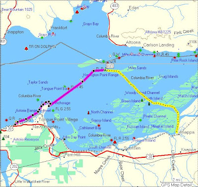
On a sunny Saturday in February a group of kayakers paddled from Astoria to Knappa Oregon via Miller Sands. There were seven of us: Jon and Kirti, Ron and Jodi, Jenny, Melody and I.

Jon Walpole planned this trip. The idea was to enjoy the open water on the lower Columbia and get a more "sea kayak" feel for the trip by paddling out to Miller Sands. The plan was to start in Astoria and use the flood current to help us on our way to Miller Sands and thence to Knappa. The flood started appr 11:30 in Astoria (Tongue Point) and slack before ebb was at appr 3pm and closer to 4:15 near Knappa. Winds were predicted to be SE 6 - 11 mph shifting to NE. Weather was predicted to be showers in the morning, clear the rest of the day. So a pretty good forecast for a day out on the Columbia.

We got on the water at appr 11:40. The day was clear and there was a good breeze blowing at the East Basin Boat Landing where we set off (appr 10 - 12 kt). Our plan was to round Tongue Point and pause to re-evaluate once we saw what the winds were like for the more open water part of our trip. If the winds were too strong we could choose to meander through the sloughs to get to Knappa, or of course turn back if need be.

The current was already flooding when we set off. We made good time to Tongue Point. The winds weren't bad at all. We rounded the point and stopped for a few minutes to do a bit of navigation to determine what landmarks we would use to paddle to Miller Sands. I'd never been to Miller Sands and at that distance I couldn't see them. I could take a compass bearing, but couldn't see where the west end of the sands were. I could see Rice Island and the SE part of Miller Sands that has trees. We figured out points we could use for navigation and set off on our crossing to Miller Sands.

The crossing felt great. It did have a very "open water" feel about it. But since the weather was so nice we didn't have much in the way of waves. Very pleasant paddling. A beautiful day, a light breeze, sometimes very small waves. The flood current definitely helped us. Jon felt that we were sometimes moving along at over 4 kt.

We had lunch on Miller Sands under a blazing February sun. After lunch we paddled over to the large part of Miller Sands (the part with the trees) and did a bit of navigation to figure out landmarks for our crossing to the islands near Knappa. Another very pleasant crossing over to Marsh Island and Karlson Island. I finally remembered to turn on my GPS at lunchtime -- we paddled this leg of the trip at just a hair over 3 kt -- which we we knew at the time because we timed how long it took to get to a navigation marker at Marsh Island. (NB: On the map above I drew the first part of the route by hand where I didn't have the GPS on.)

We then paddling along a few beautiful and relaxing sloughs to Knappa. The tide was high so the main sloughs were wide and the islands were full of little channels.

Along the way we saw I think 7 bald eagles, a couple herons, and at one point flock of hundreds of ducks took off ahead of us making a sound like a thousand shower heads raining down on the water. Just stunning.

We got off the water just before 5pm. A very nice day of paddling. 12.5 nm

For more pictures click photo:

Tuesday, February 19, 2008

North Beach on Orcas


On Sunday, 2/17/08 Kristin and I paddled along the north shore of Orcas Island. We paddled near the slack before ebb so there wasn't much current. It was a sunny day, but we had N and NW winds at appr. 15 - 20 kt, with 1 - 2 ft wind waves. We put in at North Beach and paddled west appr. 1.2 nm. We then headed back to North Beach. We paddled a zig-zag route to enjoy surfing the small waves. We were out for a just a couple hours. 3.36 nm

Saturday, February 16, 2008

Doe Bay to Lawrence Point


On Saturday, 2/16/08, Kristin and I paddled from Doe Bay around the Peapod Islands to Lawrence Point and back. We had beautiful weather: sunny, mid 50's, almost no wind. So the sea was almost like glass.

We timed the trip to be heading east on the flood and heading back west to Doe Bay on the ebb.

We saw a huge bald eagle on South Peapod, a number of seals, and a porpoise in Rosario Straight just off Lawrence Point. A very nice day to be on the water!

6.17 nm


Some pictures at:
http://picasaweb.google.com/jaybuckingham/DoeBayToLawrencePoint

Friday, February 15, 2008

Orcas: West Sound around Crane Island


We took a long weekend and went up to Orcas Island for Valentine's Day :) On Friday, 2/15/08 we paddled from West Sound through Pole Pass and around Crane Island. We got going later than we'd hoped to so we were paddling against the ebb current through Pole Pass, which was running at appr 2 kt at the time. Once we were through Pole Pass we didn't have much current against us. Then as we were heading east through Wasp Passage on the south side of Crane Island the ebb current helped us along nicely.

We were the only kayakers we saw out that day, and nearly the only boats period. As we were paddling back near the mouth of West Sound the Coast Guard came by in an inflatable boat and checked on us. It was windy and rainy at the time and it was clear they wanted to make sure we could handle the conditions. Nice to have them out there.

Weather: 40's, rainy most of the day, but we got a few periods were water wasn't falling out of the sky. Winds: S 10 kt (but sometimes we were in sheltered spots). 1 ft wind waves.

8.35 nm.

Wednesday, January 23, 2008

County Line Park to Cathlamet January 2008


On a sunny Monday in January Jon Walpole led a group of paddlers on a trip on the lower Columbia. We paddled from County Line Park (imaginatively near the county line between Cowlitz County and Wahkiakum (We-kayak-um) County) to Cathlamet. Slack before ebb was at about 1pm. The plan was to put in a bit before slack (somewhere between 11am and noon). An east wind would also propel us westward toward Cathlamet, perhaps giving us some waves to surf.

The weather prediction was for cold (high 38 F) and windy: 17 mph east wind gusting to 25 mph. Brrr! And indeed when we met the rest of our paddling team at Alder Creek Kayak parking lot bright and early this morning it was clear and a cold east wind was blowing, and we were cold in that parking lot there just shuffling boats around.

We drove to County Line Park (can’t people come up with better names for nice parks???), turned into the park, and magically slipped into an alternate universe. We got out of the cars and there was no wind. It was clear. The sun was baking down. We were warm!

Some folks shuttled a few cars down to Cathlamet Marina (our destination) and noted that near Cape Horn the wind was indeed blowing as predicted. Well, we weren’t surprised.

But at least when we started the trip we were warm and basking in a beautiful January day on the river. What luck! So on we paddled downstream in calm air and slack tide.

Just before Cape Horn (where the wind starts) we found a nice beach. We stopped for lunch to enjoy the last of the warm day with no wind. It was beautiful.

Then off for adventure! We got to Cape Horn and… no wind. Well, maybe 3 – 4 kt east wind. And by now it had turned into an ebb tide. So we had a (very) light breeze at our backs and a gentle current taking us downstream toward Cathlamet. And it stayed calm all day. Amazing.

We crossed over to Puget Island and paddled among the sloughs on the east end of the island (near Ginni's farm). We saw eagles and herons and seals, oh my.

We crossed back over to the Washington side of the Cathlamet Channel to view the waterfalls along the cliffs and avoid the breeze that was now picking up just a bit. Watched the sun set over the hills on the Oregon side and saw the full moon rise over Cathlamet.

12.6 nm.


Pictures at:
http://picasaweb.google.com/jaybuckingham/CountyLineParkToCathlametJanuary2008


Snug Harbor December 2007


I went up to the San Juans for a couple days in December 2007. I mainly went up because the little cabins at the Snug Harbor Resort on Mitchell Bay on San Juan Island are being torn down in early 2008 to build condos. So I wanted to stay in the little 1940's style cabins before they were gone for good. And of course do some kayaking up there.

Snug Harbor Resort is a great little place. (Well, for the moment.) The kind of resort that families would have gone to in the 40's and 50's when people still had time for family vacations together. It has a wide range of cabins from tiny to spacious. I rented a small cabin that had a pretty good little kitchen. The resort has a marina and a little store that sells things like coffee, the kinds of food one is likely to cook in the cabins, fishing gear, postcards, etc. It's on Mitchell Bay on the west side of San Juan Island.

On my way up there I stopped to visit Shawna and Leon on Orcas Island. And they had a beautiful new Romany in the store... spring green deck with a black hull. Very sexy. It was love at first sight. Of course I went for a walk for awhile to think about it. I went back to Body Boat Blade a few hours later and told them that yes, I wanted it.

So later that afternoon I was on another ferry heading to San Juan Island with two Romanys on top of my car :)


I paddled for two days from Snug Harbor Resort. On 12/11 I paddled to Roche Harbor for lunch. On the way back I explored Wescott Bay. The day was calm, not too cold, and the water like glass for most of the day. 8.6 nm

On 12/12 I paddled out into Haro Straight. We had about a 15 kt south wind with 1 -3 ft wind waves. The tide was flooding so the current was going north. So I paddled south against the wind and current for appr 1.5 nm and then turned back north and surfed the waves back to Mitchell Bay. I then explored every nook and cranny of Mitchell Bay since I figure I'm not likely to return here once they build condos. 8 nm

For more pictures see:
http://picasaweb.google.com/jaybuckingham/SnugHarborDecember2007