Sunday, April 19, 2009

Mayer Park to Klickitat

From klickitat_apr09


It felt like summer. We were out on the Columbia and Klickitat Rivers today between Hood River and The Dalles. Sunny, about 80 degrees. It felt great.

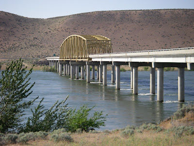
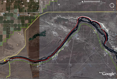
Neil and Tom organized this OOPS trip. The plan was to put in at Mayer State Park near Rowena Oregon (near The Dalles) and paddle across the Columbia to the Klickitat, up the Klickitat to the first few rapids and play there til the afternoon west wind built up in the Gorge. Then return to the Columbia and surf the wind waves back to Mayer Park.

Well, by this morning it was pretty clear that the typical west wind was not going to materialize today. So Neil suggested we just spend the day playing in the moving water at the first few rapids on the Klickitat. Practicing peeling out of eddies, ferry gliding, etc.

It was a beautiful day. Sunny, blue skies. No wind.

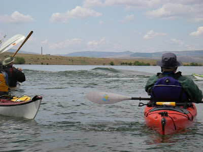
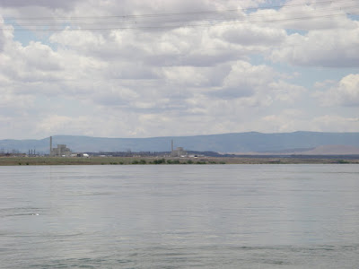
There were eight of us total. Neil and Tom, Bob, Jay (another one), Ken Scholtz, Dave and Karen Dalbey and me. We got on the water a bit after 10am and paddled across the Columbia to the mouth of the Klickitat and headed upstream. I mentioned to Karen "Hey, this paddling upstream isn't bad". She noted that I probably shouldn't have said that...

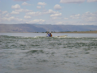
We got up to the first fast water and all put our helmets on. Played for awhile in the first eddy and eddyline. Then worked to get up to the next eddy. Felt like work at the time anyway. We played on that eddyline a bit as well. There was a nice beach above the fast water and Neil worked pretty hard and took a fair while get to it. Looked like alot of work. Then Tom informed us that that was our intended lunch spot. And if we didn't get there we couldn't eat :) Great motivational speaker.

Dave Dalbey went for it and got there pretty handily. Looked like the key was to have alot of speed crossing the eddline and cross the eddyline to ferry across rather than turn in any way downstream.

I went for it. I had good speed crossing the eddyline and ferried to the other side fairly easily. Then got bogged down in the fast current near the rocks on the other side. Just couldn't make any progress. I was out of energy when Neil pointed out a little eddy I could rest in. Got it. Rested a minute then pulled hard for the last 20 or 30 yards to the beach. That was exercise. I was tired and ready for lunch!

That beach was a great spot for lunch.

After lunch most folks went up to the next set of rapids. I was enjoying the beach alot so napped a bit. Once they all came back we played for quite awhile in the current near our lunch beach. I hadn't been in current in a sea kayak since last summer so it was great to get the practice. And nice to do it on such a warm day so if one dumped ones boat the water felt great. Most folks were rolling periodically just to keep cool.

Finally we headed back. We floated lazily down the last bit of the Klickitat down to the Columbia. The area is just beautiful this time of year. Still green and fresh with spring. Lots of flowers. Hawks and eagles and osprey, oh my. I saw a nice steelhead jump a couple times.

Got back to the Columbia and as expected no wind. But it was a pleasant paddle upstream the short ways back to Mayer State Park. A good group of folks and a good day on the water.

Sunday, March 29, 2009

Dalton Point to Chinook Landing

From DaltonPoint_090329


On a gray and sleety morning in late March an intrepid band of OOPS kayakers launched from Dalton Point on the Oregon side of the Columbia (near Multnomah Falls) headed toward Chinook Landing (near Fairview, Oregon).

Tom Argent and Neil Schulman did a great job of organizing this trip. There were eight of us altogether: Tom, Neil, Mike, Bob, Kevin, Becky, Stacy and myself. We met and Chinook Landing and did all the shuttle stuff to get us and boats up to Dalton Point. We launched at appr 10am and paddled across to Phoca Rock. We explored around it a bit, then headed over to Cape Horn on the Washington side and really enjoyed exploring that area. The cliffs and waterfalls there were beautiful.

As we left Cape Horn and headed west we got a bit of west wind, but not much. Maybe 8 mph. Sometimes it was there, sometimes not, til we got to Reed Island.

We paddled on the north side of Reed Island to find a lunch spot. No wind at all on that side. By now it was warm and sunny. A very relaxing lunch.

After lunch we headed to the west end of Reed Island then threaded our way through the maze of drift nets. I find it hard to believe that commercial salmon fishing with nets is still allowed in the Columbia given the precarious state of these salmon runs. Sure, commercial salmon fishing in Alaska still makes sense. But not on the Columbia. With millions of people out of work in this country it's impossible to justify keeping a couple thousand fishing jobs (at most) that threaten these fish with extinction. People will live. Extinction is forever.

But eventually we crossed the Columbia and paddled behind Gary Island, then along the outside edge of the Sandy River Delta. While paddling in that shallow brush-filled water a large carp hurled itself at Stacy's boat. It made a "twack!" that was audible for quite a ways and a nice large splash! That really got her attention :) Just like the carp Kristin and I encountered in Scappoose Bay.

From there it was on to a few large rocks (with power pylons on them) at Troutdale. We found a nice eddyline coming off one of those rocks and stopped there to play for awhile. A nice warm day, a fun little eddyline... life is good.

But eventually it's time for all of us to get home so we headed west the now short distance back to Chinook Landing. We landed at appr 17:00.

According to Mike's trusty GPS: 17.7 miles. A good day on the water.

From DaltonPoint_090329

Friday, February 20, 2009

Valentine's vacation at the beach

From Nahcotta


Kristin and I had both been working alot lately and she had some vacation time she had to use (use it or lose it). We wanted to get out into nature, do some paddling, and eat healthy food to rejuvenate ourselves. But we couldn't afford to go too far. So we decided to head to the Long Beach Peninsula for a few days.

We headed out on Sunday Feb 15 after Valentine's Day, pointing the car in the direction of Astoria. We stopped for a nice paddle from Knappa on the way.

From Nahcotta


That was about 5.4 miles.

Definitely enough so we were ready for dinner! In Astoria we stayed at Clemintine's B&B, which was lovely. We showered and headed to Baked Alaska for dinner -- the first of our seafood dinners of the trip. So far, the trip was going according to plan: nature, exercise, healthy food. I love it when a plan comes together.

The next day we had a nice breakfast at the B&B and then meandered around Astoria in the morning. I'd been to Astoria a couple times in the past year or so in the course of several kayak trainings, but had never explored the town. At those classes we always did our wrapup at the Fort George Brewery, which is a great way to wrapup a kayaking day. (Well, not always... on our night navigation class last summer that went from Aldrich Point to Astoria we didn't get to Astoria til after 2am, at which time the pub was closed. I really could have used a beer about then too.)

So on this sunny February day Kristin and I wandered the town and toured the Flavel Museum -- very worthwhile. And hit up the Blue Scorcher Bakery for bread for the trip.

We then got in the car and headed north. Stopped in Ilwaco for lunch -- more seafood! Then bought fresh seafood from a local market to cook at our cabin for the next couple days.

We stayed at Shakti Cove Cabins, which are very peaceful. Just the kind of relaxing setting we needed. Kristin made a great dinner of prawns and sole.

We wanted to paddle Willapa Bay. We'd never done that. But on the days of our trip the tides were not in our favor. High tides at about 7 am. Low tides were about 1 - 2 pm. And Willapa Bay has lots of mudflats at low tide. Very easy for boats to get stranded in the mud til the tide comes back up. But if you stay in the narrow channels that are deeper, the current can be very strong, sweeping you out toward the bar, and you really don't want to go there.

So we got out on the water early on Tuesday morning to avoid low tide. Put in at Nahcotta. And paddled east to Long Island. Take a look at the GPS track of that trip and you'll see that the ebb did push us a bit north at first til we figured out how strong it was.

There was still plenty of water when we got to the island. Nice river rock beach. Yeah! We walked around on the island for awhile. Lots of elk tracks. But didn't want to stay long since the tide was ebbing. By the time we left the boats were high and dry. We had to carry them across a good bit of mud to get back to the water.

Our plan was to paddle south against the ebb in the shallow water near Long Island to avoid the strong ebb current in the channel, then head west across the channel and let the ebb take us back to Nahcotta. And our plan worked. We had an amazingly calm February day. We took advantage of the beautiful weather to practice technique in the clear shallow water near Nahcotta. Yep, saw lots of oysters.

Trip: 6.45 mi.

We were back to Nahcotta about noon. So we relaxed, walked around Ocean Park and the beach there, and Kristin made another great dinner. This time fresh crab and greens. Yep, more healthy local food :)

From Nahcotta

Friday, December 12, 2008

Skamokawa Center Farewell

From Skamokawa_081211


From Skamokawa_081211


I was very sad to hear that Skamokawa Center was going bankrupt. I really like all the people there. It's such a great spot to start a kayaking trip. You can do such a variety of interesting trips from there. Lots of great wetland trips on the sloughs. Much more open water trips on the Columbia. Journeys like paddling from Skamokawa to Astoria.

So the day before they closed I went down there to paddle from their dock one last time. The tide was flooding in the morning and would start to ebb about 1pm. So I headed toward Cathlamet and turned around with the ebb. I took a break on the beach just NW of Hunting Island.

It turned out to be a beautiful winter day. For awhile I had an east wind of maybe 5 or 6 mph that helped me (ever so slightly) paddle back to Skamokawa.

Once I got back, the folks at Skamokawa Center fed me freshly baked cookies. Yum...

I wish I had the wealth to buy the place. It already has a good team to keep it running. Just needs a bit more marketing to get a few more kayakers coming up there. I could live there and retire there!

From Skamokawa_081211

Saturday, June 28, 2008

Ilwaco to Warrenton


The last weekend of June 2008 John Sindelar and I took a Dynamic Water Workshop with Ginni.

On Friday June 27 we focused on surf and swell practice on the Pacific side of Cape Disappointment State Park at Benson Beach. It was definitely the largest surf I had ever paddled in. My guess: 5 - 6 foot waves. Ginni... what was it actually? Turns out I'm not in good enough shape to paddle out through the surf many times so while John was surfing in and paddling back out I stayed out beyond the surf in the swell with Ginni and we worked on paddling skills in the swell. It was a nice 3 - 4 foot swell, which was perfect for me to practice edging, turning, paddling backwards, etc. When I did surf in, I felt pretty good. I managed to paddle backwards hard several times to allow waves to pass under my boat that I didn't want to surf. I surfed some smaller waves and had lots of fun. And I was thrilled that when I dumped my boat a couple times each time my roll worked! I didn't come out of my boat the entire day.

The wind really kicked up in the afternoon so after lunch we went over to Waikiki Beach in search of less wind to do a little rock gardening. But it was still pretty windy there -- appr 25 kt north wind. I went out a little, but not very far.

The wind for Saturday was also predicted to be strong: N 20 - 30 kt. So that evening we were all sitting in the Sea Hag bar in Ilwaco with charts spread across a table trying to figure out what kind of trip we could do on Saturday to give us good "learning" situations but still be survivable. That was the trip planning part of the class. We studied the charts, checked the tide and weather predictions, detailed the hazards, and compared what we wanted to work on with what was doable. We decided that we'd do a journey, paddling from Ilwaco across the mouth of the Columbia River to Astoria. During the time we'd be paddling there would be a fair bit of current, but the wind from the NW would way more than overcome that. So the plan was we'd be surfing wind waves to Oregon. Way fun and great learning. As a backup we would leave a car in Warrenton at the Skipanon Marina in case we didn't want to paddle across the mouth of Youngs Bay all the way to Astoria.

So Saturday morning rolls around, we do a car shuttle to leave a car in Astoria and Warrenton and drive back to Ilwaco. During the drive we notice that it's not windy at all yet. Fine so far. Then we launch our kayaks at the boat launch in Cape Disappointment State Park (near downtown Ilwaco) and set out toward Oregon. Still no wind. That's ok. We got to the south end of Sand Island and started to feel the beginning of the ebb. Still no wind.

We were seeing all kinds of birds by now. Lots of pelicans, gulls, terns. Ginni gave us much detailed information on the terns.

Our plan was to have lunch at the marina in Hammond. We headed toward Buoy 21 to get there. We encountered more ebb current and still no wind at our backs. And the sun is baking down on us as we paddle against the current. For a couple hours. During this segment of our fun filled journey I was consistently falling behind. I hate to hold up a group. I was not happy. It was very difficult for me to maintain the paddling pace to keep up with the group. So it became clear that the key thing I need to work on now to be a better paddler is just to get in better shape. Ginni was very helpful with tips on forward stroke and we paddled in line so I could draft off the others.

We got to Buoy 21 and the beach on Clatsop Spit in Fort Stevens State Park looked very close. We decided to have lunch there instead of Hammond. We took a few photos and were off.


We made it across the Columbia and stopped on the beach at the NE tip of Clatsop Spit (nearest spot to Buoy 21) for lunch. As we got to the beach there were plenty of people in swimsuits enjoying the hot Saturday afternoon. John and I peeled the top of drysuits off our bodies to cool off a bit. Lunch was great.

Finally the wind picked up from the NW. And we were off again, heading SE toward Astoria with the wind at our backs and moving along nicely with very little effort. Finally we were cruising along at 4.5 kt :)

But the wind died down after about an hour and the rest of the trip was just paddling upstream. We stayed near the shore to be in minimal current and found a few eddies as well. I was getting pretty tired so we ended the trip at the Skipanon Marina.

We did a bit of car shuttle to get the boats back to Ilwaco, discussed the day, and I headed home. As I was driving across the bridge to Astoria I noticed a brisk west wind had developed.

Though I was pretty tired, it was a good paddle trip for me -- I'd never crossed the mouth of the Columbia via kayak before! Definitely an achievement.

Date: 6/28/06
Launch time: 10:00
At south end of Sand Island: 10:54
Lunch on shore: 12:45
Launch after lunch: 14:00
Off the water: 16:00
Distance: 11.4 nm
Avg speed: 2.3 kt
Max speed: 5.6 kt
Moving time: 5 hrs


CurrentSand IslandHammond
Slack10:2210:21
Max Ebb12:0012:47
Slack16:0016:20


Sunday, June 15, 2008

Hike up Palmer Snowfield


We've been doing a fair bit of kayaking but haven't been exercising our legs much this spring, so we want to get out and do some hiking to help with that. We wanted to find out what kind of shape we were in for hiking. And we wanted to do a hike that would remind our legs what it was like to go uphill. So we decided to hike up the climbers trail from Timberline Lodge and just hike up the Palmer Snowfield until we got tired.

So on a beautiful Saturday in June we did just that. Our plan was to start early enough in the morning so that the snow was very firm, but late enough so it would be softer for the hike downhill. We left Timberline Lodge at 7:30 and started hiking up the climbers trail. The snow was perfect. Nice and firm, but not icy. It was sunny, cool, but not cold.

We hiked to the top of the Magic Mile and stopped for a break. We continued on and had a couple more breaks along the Palmer. Ended up stopping near the top of the Palmer. Kristin had some leg problems and I had a very sore right ankle and was starting to get blisters on the insteps of both of my feet. Just where I usually get blisters. Fine, this was intended to be an initial hike to figure out what we need to work on. So I need to figure out what's up with that ankle and remember to put moleskin on at the beginning of the hikes. We both had energy to keep going, which is encouraging.

We enjoyed talking with the people who had climbed the mountain earlier in the day and were hiking down. It sounded like a great day to climb. Cool and clear and not windy at night. Snow firm at dawn for summiting. Great views at the summit.

And it was entertaining to see how differently people were feeling. Some were perky and energetic and clearly were still having fun. Others... well, it looked like a death march for them. You could so easily feel the differences in their energies. Both the perky people and the exhausted ones inspired us to get into better hiking shape.

So we want to do this hike more times this summer. It's both a great training hike and has beautiful views. And since we'd like to climb Hood again sometime, this hike gives us a clear view of how close we are to being in good enough shape to do it. Once we get into better shape, we want to take the Bibler up and camp somewhere above the top of the Palmer. Carrying a backpacking pack up to say Illumination Saddle would help us get into better shape!


The hike down was easy. The snow had indeed softened making it easy on the joints going downhill. Got back to the car and headed home.

Notes for future such trips. Need gaitors, better sunglasses.

Date: 6/14/08
Start: 7:30
Back to car: 13:30
Time moving: 3 hr 10 min
Distance: 4.0 miles
Elevation gain: appr 2200 ft
Avg speed: 1.27 mph

Monday, June 2, 2008

Hanford Reach June 1 2008


On a beautiful Eastern Washington sunny Sunday a group of OOPS paddlers kayaked part of the Hanford Reach of the Columbia River. This was a scheduled OOPS trip led by Pat Daly and co-led by Tim Mattson and Don Beale. The rest of us paddlers were: Dave Beckett, Frank Blangeard, Jay Buckingham, Ed Kraft and Greg (didn't catch his last name).

I'd heard about the Hanford Reach of the Columbia for years. The last free-flowing non-tidal stretch of the Columbia in this country. Pretty much undeveloped due to it being a restricted area since the 1940's. Well, except for an old reactor here and there. Basically a wildlife refuge now. I've wanted to visit there for a long time. So when I saw that an OOPS trip was going there I was really excited. And I was thrilled when I heard that it was being led by Pat Daly, a guide who really knows the paddling in that area.

The plan was to launch near Vernita Bridge (where Washington Highway 24 crosses the Columbia about 30 miles north of Richland). We would then paddle about 21 miles of the Hanford Reach and take out at the White Bluffs boat ramp.

We met at the beach on the north side of the river just west of Vernita Bridge, got boats and gear situated, then did the car shuttle to the take-out. We got on the water about 11am.


The water was pretty high (not surprisingly), running at appr 200,000 cfs. So once we got paddling we were moving -- soon about 6 - 7 kt. Though there was alot of water, it looked pretty clean to me. Often a few upwellings here and there. And some nice crisp eddylines. With the current it was pretty easy paddling watching the scenery breeze by.

I borrowed a Greenland paddle from Don. I'd used one for the first time at OOPTIKS and really enjoyed it. Now I wanted to know how it would feel to use one on an all-day trip. Short story: I loved it.

After about 4.5 miles we got to Reactor B, the first of the large-scale plutonium production reactors. It's of course closed down now. The juxtaposition of the undeveloped desert landscape and these Cold War edifices was striking. Also striking was the wildlife. Since non-Hanford people are allowed on such a small fraction of the Hanford Reservation area, animals pretty much have it to themselves. We saw lots of deer, some otter, some large fish, and lots and lots of birds from hawks to geese to swallows.

About 6 miles from the launch we got to Coyote Rapids. Pat described the rapid to us and we all decided that yes, it sounded like alot of fun. We were told that at typical flow levels it's not much of anything, but given the high water we had it might be fun. The rapid can be easily avoided by going river left, so of course we were all hugging river right. We got to a little riffle and Tim and Don stopped to play in it. Pat called them onward: "Hey, the real rapid is down there!" There hadn't been much life-threatening excitement thus far on the trip so they were taking advantage of every feature they could find. But when we got to the rapid... we were all impressed. A couple nice clean waves with some bouncier waves behind. And a nice big eddy on river right that allowed easy access to the rapid. Again and again :)


We played there for quite awhile. The Hanford folks could do great things with that location... I'm thinkin a little parking area, we don't need a fancy launch site, just put kayaks in using the river's beach either above the rapid or in the eddy, a nice cafe selling cappuccino and ice cream with a deck to watch the kayakers play in the rapid, a barbecue place and microbrewery, maybe some cabins and a B&B...

I went through the rapid four or five times. It was my first time working with strong current and rapids using a Greenland paddle. I was pretty happy with it. Bracing worked very well. Stern rudder worked well. Had a bit more trouble getting up to speed quickly. Once I managed to get across to the smooth waves and surfed for just a bit. I'm sure it wasn't very long, but it felt great. Anyway, I had a great time. I could have stayed there all day. Like Deception Pass, but with sunshine!

After the rapids we continued our fast and easy trip to our lunch spot. More wildlife, more sunshine, a couple more old reactors, some dead-fish polo.


We stopped for lunch at the point where the river bends to the south (see map). Yep, still sunny.

After lunch we paddled pretty much south along the White Bluffs. Beautiful scenery, and very different than the Lower Columbia where I paddle so often. Kayaking in the desert, a nice change.


As we got closer to our take out a S wind kicked up against us, making us work a bit for the first time that day. Since the wind slowed me down I was able to really focus on various aspects of my forward stroke using the Greenland paddle.

We got the the take out, which is one end of an old ferry route, got boats and gear packed up, and we all headed for home. A really nice day on the river!

On the water: 11:05
Off the water: 15:50
Distance: 18.4 nm
Max speed 11.1 kt
Average speed 4.9 kt